


Calibration, Validation and Application of
geostationary ocean color satellite
Date
- The cruise with Ocean Research II on Nov. 30 and Dec 1, 2013.
Purposes
- Using HyperSAS, AC-S, ECO-VSF and in situ water samples to collect the sea truths for calibrating and validating GOCI data.
- Collecting the sea surface remote sensing reflectance by shipborne hyperspectral meter to retrive IOPs and water quality from the hyperspectral data.
Measurement
- Bio-optical set (AC-S+Eco-VSF+DH-4+Power)
- Remote sensing reflectance (HyperSAS)
Processing steps
We aim to collect water samples, IOPs and remote sensing reflectance data on sea surface around Danshuei River (DSR) mouth in the north of Taiwan and all these works are supported by the research ship: Ocean Researcher II (ORII).
The instruments on ORII used in this field experiment including the spectral attenuation meters (WET Labs, AC-S), volume scattering function meter (WET Labs, ECO VSF), and shipborne hyperspectral meter: Hyper Surface Acquisition System (Satlantic, HyperSAS).
The spectral attenuation meters, AC-S measures attenuate and scattered spectra with about 4 nm resolution from 400 nm to 730 nm and volume scattering function meter, ECO VSF measured backscattering coefficient with three wave length about 470 nm, 530 nm and 660 nm. Both AC-S and ECO VSF are set in a cage and put under sea surface about 2 m by a capstan in the stern of ORII. The laser diffraction instrument, and put under sea surface about 2 m by a capstan in the shipboard of ORII. The shipborne hyperspectral meter, HyperSAS measures sea surface remote sensing reflectance with about 3 nm resolution from 400 nm to 700 nm and it is set at the bow of ORII.
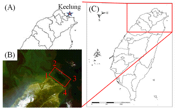
This field experiment will start from 8 AM to 4 PM on Nov. 30 and Dec 1, 2013. We will select 6 to 8 sites without cloud covering to process the experiment in the region as circled in the red square in Fig. 1 (B). We will spend about 20 minutes in each site to collect the in situ data.
Figure 1 study area in Taiwan
Table 1 The longitude and latitude coordinate of experiment region as Fig. 1 (B)
Study area region pointsLongitude
Latitude
1
121.562609°
25.353745°
2
121.715647°
25.514389°
3
122.266682°
25.254523°
4
25.052778°
Expected results
The in situ water samples will be collected such as water quality, IOPs. Meanwhile, the remote sensing reflectance Rrs on the water surface will be measured by the shipborne Hyper Surface Acquisition System (HyperSAS) to derive the IOPs and water quality.
HOME |
|
| No.1, University Road, Tainan City 701, Taiwan (R.O.C.) Tel:06-2366740 Copyright ©2013 Global Earth Observation and Data Analysis Center. All rights reserved. |